
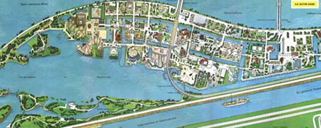
Tourist map Expo 67
The study of the installations at the Montreal Universal and International Exhibition of 1967 (EXPO 67) aims to highlight the contribution of Canadian landscape architects to this event and identify the landscape elements that bear witness to this recent heritage period. More than a dozen Canadian landscape architecture firms played key roles in designing the Ile Notre-Dame, Ile Sainte-Helene and Cite du Havre sectors, from the structure of the islands to plant selection. Although the significance of Expo 67 to the profession is widely recognized, the extent of participation of landscape architects is not well documented. Phase 1 of this project was awarded an LACF grant in 2011. Research was undertaken to interview a number of the landscape architects involved in the overall masterplan for the site. This second phase will assemble the transcribed interviews along with other archival materials, drawings, then/now photographs into a publication, presentation and journal articles that tell the contributions by landscape architects in both official languages.
In addition, the results of Phase 1 have shown how Expo ’67 has affected the practice of landscape architecture in Canada. Montrealer’s consider the site of the exhibit a precious asset. Several of the architectural elements have been designated as heritage sites at both municipal and provincial levels; however, none of the landscape components have been specifically designated, much less recognized as the backbone of the overall success of the Expo and park system that remains. With preparations for the 50 th anniversary of Expo 67 underway and the master plan for the islands under review, this study aims to recognize a significant milestone in heritage landscape management decisions.
* Awarded the Gunter Schoch Bursary (GSB)
Published Articles: